Revolutionizing Urban Analysis
Join us on our mission to shape the future of cities worldwide.

Join us on our mission to shape the future of cities worldwide.


AutoDash provides automatic data collection, reducing the need for expensive human resources and time-consuming data gathering processes.
Automating data collection minimize manual efforts and reduces the chances of errors. At the same time, you speed up the overall analysis process freeing up your team for more strategic tasks.
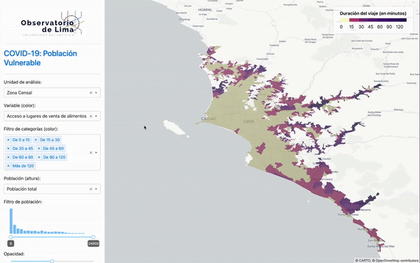
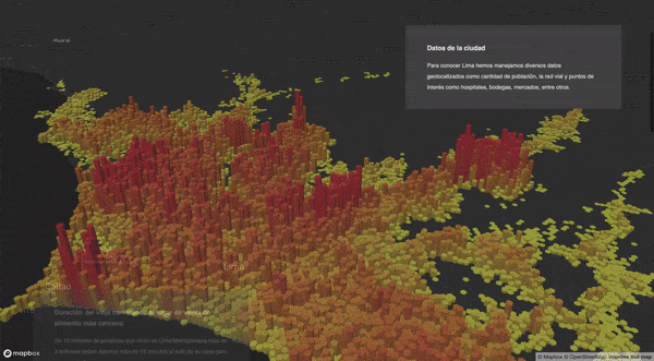
Transform complex data into easy-to-understand visualizations to make informed decisions.
Turn complex, raw data into personalized visualizations, making it easier for you to draw insights and to make data-driven decisions that align with your objectives.
Scale your analysis and benchmarks to any geographical area in the world.
A truly global solution for urban analysis. Whether you're analyzing data for a small town or a mega city, AutoDash adapts to your needs with consistency and performace.
Built on the foundation of our open-source software, UrbanPy, AutoDash stands for the democratization of high-quality data and information.
View on GitHubBuilt on open-source software, AutoDash offers transparency, allowing you to see and understand how the software works and ensure accessibility to all.
We foster Open Source at our core
Our platform brings together advanced technology and comprehensive datasets to revolutionize urban analysis.
UrbanPy is helping city governments, researchers, and analysts to build custom geospatial analyses from weeks or months to minutes or hours.
Allows easy access to worldwide open data from trusted sources integrating it seamlessly into your analysis tools.
By automating data collection and processing, AutoDash significantly lowers the cost of updating analysis results periodically.
"Urbanpy is a transversal tool that can help policymakers design policies based on data."

"We created a spatial (accessibility) model from school locations and demographics for two Brazilian cities right out of the box with the UrbanPy software."

AutoDash is a platform that automates the data collection, processing, and monitoring of geospatial indicators for urban analysis.
AutoDash is designed for government agencies, urban planners, real estate developers, and anyone interested in data-driven urban analysis.
AutoDash helps address various sustainable development goals by providing data-driven insights on issues like housing, transport, environmental impact, public spaces, and education.
Join us reshaping the future of our cities.
Get Started